Modern sonar technology is revolutionizing archaeology by revealing ancient cities, shipwrecks, and lost civilizations hidden beneath water and earth for millennia.
🔍 The Revolution of Underwater Archaeological Discovery
The intersection of cutting-edge sonar technology and archaeology has opened unprecedented windows into our past. What once required decades of manual excavation can now be mapped in weeks, revealing entire landscapes that have remained concealed for thousands of years. This technological leap is transforming how we understand ancient civilizations and their magnificent achievements.
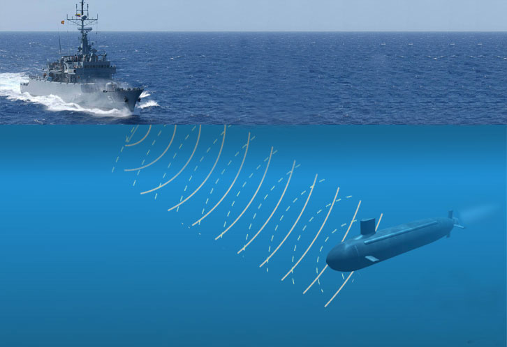
Sonar mapping, particularly multibeam and side-scan sonar systems, has become the archaeologist’s most powerful tool for underwater exploration. These technologies emit sound waves that bounce off objects and terrain, creating detailed three-dimensional maps of underwater environments. The precision has improved dramatically, with modern systems capable of detecting objects as small as a few centimeters from depths exceeding thousands of meters.
Ancient Cities Rising from the Deep 🏛️
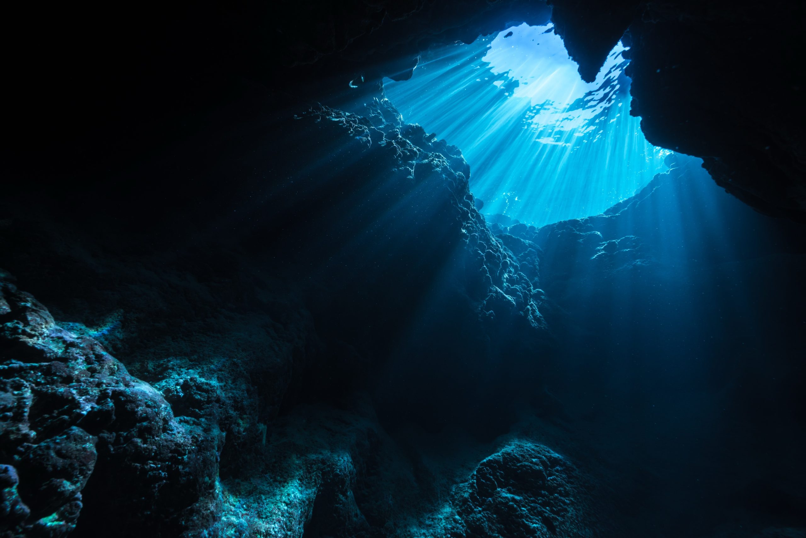
One of the most spectacular applications of sonar mapping involves discovering submerged ancient cities. Rising sea levels, earthquakes, and geological shifts have claimed numerous settlements throughout history. The Mediterranean Sea alone harbors countless lost cities, many unknown until sonar technology made their detection possible.
The legendary city of Heracleion, lost for over 1,200 years beneath Egypt’s Abu Qir Bay, serves as a prime example. Advanced sonar mapping revealed the city’s layout before divers confirmed the presence of colossal statues, temples, and harbor structures. This discovery rewrote significant chapters of Egyptian maritime history and revealed the importance of this once-thriving port city.
Mapping Techniques That Changed Everything
The evolution of sonar technology has been remarkable. Early systems provided basic depth readings, but modern multibeam sonar creates incredibly detailed bathymetric maps. These systems use multiple sonar beams simultaneously, covering wide swaths of ocean floor while maintaining high resolution. Side-scan sonar complements this by providing photographic-like images of underwater features.
LiDAR technology, when combined with sonar, offers even more comprehensive mapping capabilities. While sonar works underwater, LiDAR penetrates jungle canopies and vegetation, revealing structures hidden by centuries of growth. This combination has proven particularly valuable in Central America, where Mayan cities lay concealed beneath dense rainforest.
The Secrets of Shipwreck Archaeology ⚓
Ancient shipwrecks represent time capsules of human history, preserving cargo, tools, and artifacts that illuminate trade routes, technological advancement, and cultural exchange. Sonar mapping has exponentially increased the discovery rate of these underwater museums, with thousands of previously unknown wrecks now documented.
The Black Sea, with its unique anoxic waters that preserve organic materials, has become a treasure trove of shipwreck discoveries. Sonar surveys have revealed vessels dating back over 2,500 years, some preserved so well that rigging and deck structures remain intact. These discoveries provide unprecedented insights into ancient shipbuilding techniques and maritime trade networks.
Trade Routes and Economic Networks
Mapping shipwrecks along ancient trade routes has revealed the extent and sophistication of historical economic networks. Roman amphorae found scattered along Mediterranean sea lanes, Chinese porcelain discovered in East African waters, and Phoenician cargo vessels in the Atlantic all tell stories of global commerce that predated modern globalization by millennia.
Each wreck site mapped by sonar adds pieces to the puzzle of how ancient societies traded, communicated, and influenced one another. The distribution patterns of artifacts help archaeologists understand everything from commodity values to geopolitical relationships between ancient civilizations.
🗺️ Revolutionary Discoveries in Lakes and Rivers
Freshwater environments have yielded equally impressive discoveries through sonar mapping. Lakes and rivers served as highways for ancient peoples, and many settlements developed along their shores. When water levels rose or landscapes changed, these sites became submerged archaeological parks.
Lake Titicaca, straddling the Peru-Bolivia border, conceals pre-Incan ceremonial sites that sonar mapping has begun to reveal. Stone structures, offering tables, and artifacts rest beneath the waters, providing evidence of sophisticated ritual practices and architectural achievement at high altitude. These discoveries challenge previous assumptions about the capabilities and reach of Andean civilizations.
Sacred Sites Beneath the Waves
Many ancient cultures considered bodies of water sacred, conducting ceremonies and depositing offerings in their depths. Sonar technology has revealed countless ceremonial sites, from Maya cenotes containing sacrificial objects to Scottish lochs harboring Bronze Age weapons and jewelry.
These underwater sacred spaces often preserved organic materials and delicate artifacts that would have deteriorated in terrestrial environments. The anaerobic conditions found in certain underwater locations create preservation conditions superior to dry land, maintaining wood, textiles, and even biological materials for thousands of years.
Technology Behind the Treasure Hunt 💻
Understanding the technology driving these discoveries helps appreciate the magnitude of this archaeological revolution. Modern sonar systems employ sophisticated signal processing, artificial intelligence, and machine learning algorithms to distinguish archaeological features from natural formations.
Autonomous underwater vehicles (AUVs) equipped with sonar arrays can survey vast areas without human pilots, following pre-programmed routes or adapting their paths based on real-time data analysis. These robots work tirelessly in conditions too dangerous or remote for human divers, gathering data that would have been impossible to collect just decades ago.
From Data to Discovery
Raw sonar data requires extensive processing before archaeologists can interpret it. Specialized software filters out noise, corrects for water conditions, and enhances features of archaeological interest. Machine learning algorithms trained on known archaeological sites can now flag potential targets automatically, dramatically reducing the time researchers spend analyzing data.
The integration of geographic information systems (GIS) allows archaeologists to layer sonar data with historical maps, geological surveys, and environmental data. This multidisciplinary approach creates comprehensive models of ancient landscapes, revealing not just where structures existed but how they related to their environment and one another.
🌊 Challenges in Underwater Archaeological Mapping
Despite technological advances, sonar mapping faces significant challenges. Water conditions profoundly affect sonar performance, with temperature layers, salinity variations, and suspended particles all degrading signal quality. Deep water requires more powerful systems, while shallow coastal areas present navigation hazards and complex acoustic environments.
Distinguishing archaeological features from natural formations remains difficult. Rocks can resemble building foundations, geological features may appear as walls or roads, and modern debris often clutters sites of ancient activity. Experienced archaeologists must verify sonar findings through visual inspection or excavation, a time-consuming and expensive process.
Preservation Versus Exploration
The discovery of ancient sites raises complex ethical questions about preservation and access. Underwater environments often provide excellent preservation, and disturbance from diving or excavation can accelerate deterioration. Many archaeologists advocate for in situ preservation, documenting sites with sonar and photography while leaving artifacts undisturbed.
Looting represents another serious concern. When sonar mapping reveals valuable archaeological sites, this information can attract treasure hunters and illicit artifact traders. Balancing scientific transparency with site protection requires careful management and sometimes keeping locations confidential.
Case Studies That Rewrote History 📚
Several sonar mapping projects have produced discoveries so significant they fundamentally altered our understanding of ancient civilizations. In Guatemala, LiDAR surveys combined with sonar mapping of waterways revealed a Maya megalopolis far larger and more complex than previously imagined, with elaborate water management systems and defensive structures housing potentially millions of people.
Off the coast of Greece, sonar mapping discovered the Antikythera mechanism site and numerous other wrecks, revealing the sophistication of ancient Greek technology and the hazards of ancient navigation. The mechanism itself, an ancient astronomical calculator, demonstrates computational capabilities that wouldn’t be matched for over a millennium.
Redefining Civilization Timelines
Sonar discoveries in the North Sea and English Channel have revealed extensive landscapes that were dry land during the last ice age, complete with settlements, hunting camps, and artifacts. These findings push back evidence of human habitation in northern Europe and provide insights into how prehistoric peoples adapted to dramatic climate change as sea levels rose.
In the Americas, underwater surveys have located pre-Columbian harbors, fish weirs, and settlement patterns that demonstrate sophisticated resource management and social organization. These discoveries challenge narratives about the development of complex societies and highlight the achievements of indigenous peoples.
🔮 The Future of Sonar Archaeological Exploration
Technological advancement continues accelerating, promising even more spectacular discoveries ahead. Quantum sensors may soon detect subtle gravitational anomalies caused by buried structures, while advanced AI could predict likely archaeological sites based on environmental and historical data patterns.
Satellite remote sensing combined with predictive modeling helps researchers identify promising survey areas before deploying expensive sonar equipment. This approach increases efficiency and allows exploration of remote locations that would otherwise remain unstudied due to logistical constraints.
Democratizing Archaeological Discovery
As technology becomes more accessible, citizen science initiatives are emerging in underwater archaeology. Amateur enthusiasts equipped with affordable sonar units are discovering shipwrecks and reporting findings to authorities. While this raises concerns about site protection, it also exponentially increases survey coverage and engages public interest in cultural heritage preservation.
Virtual reality reconstructions based on sonar data allow anyone to explore ancient sites without diving equipment or specialized training. These digital experiences bring archaeological discoveries to global audiences while supporting conservation efforts by reducing physical visitation to fragile sites.
Global Collaboration and Data Sharing 🌍
Modern archaeological projects increasingly involve international teams sharing data and expertise. Standardized data formats allow sonar surveys from different regions to be compared and integrated into global databases. This collaborative approach accelerates discovery and ensures that findings benefit the entire scientific community.
Countries are developing legal frameworks to protect underwater cultural heritage while enabling research. UNESCO’s Convention on the Protection of Underwater Cultural Heritage provides guidelines for responsible exploration and prohibits commercial exploitation of archaeological sites. These international agreements help preserve shared human heritage for future generations.
The Human Stories Behind Ancient Ruins 👥
Beyond structures and artifacts, sonar mapping ultimately helps us understand the people who built these ancient wonders. Each mapped city, shipwreck, or ceremonial site represents human ambition, ingenuity, and daily life across millennia. The pottery scattered across a Bronze Age shipwreck speaks of merchants seeking profit, the precise alignments of submerged temples reveal astronomical knowledge, and the distribution of settlements shows how societies organized themselves.
These discoveries connect us to our ancestors in profound ways, demonstrating that humans have always been explorers, builders, and dreamers. The same impulses that drove ancient mariners across unknown seas now propel us to uncover their stories using technology they could never have imagined.
Transforming Our Understanding of the Past 🎯
Sonar mapping has fundamentally transformed archaeology from a discipline of slow, incremental discovery to one capable of revealing entire civilizations in single survey seasons. This acceleration creates both opportunities and challenges, providing vast amounts of data while demanding new analytical approaches and preservation strategies.
The hidden treasures revealed by sonar technology extend beyond gold and artifacts. The true treasure lies in knowledge—understanding how ancient peoples lived, what they valued, how they overcame challenges, and what ultimately led to their decline or transformation. Each sonar image that pierces murky waters or penetrates jungle canopy brings these human stories into focus, enriching our collective heritage and reminding us that our own civilizations will one day be subjects of similar archaeological curiosity.
As technology continues advancing and more of Earth’s unexplored regions yield their secrets, the coming decades promise discoveries that will continue reshaping our understanding of human history. The ancient ruins waiting beneath waves and wilderness represent not just remnants of the past, but bridges connecting us to the remarkable journey of human civilization across time.

Toni Santos is a visual storyteller and educational ethnographer whose work celebrates the fluid knowledge systems of nomadic cultures. Through art and research, Toni brings attention to how learning has thrived outside traditional institutions—rooted in movement, oral tradition, and deep connection to land and community.
Guided by a passion for ancestral wisdom, adaptive pedagogy, and cultural resilience, Toni explores the tools, rituals, and environments that once shaped the minds of travelers, herders, and migrating communities. Whether illustrating storytelling circles beneath open skies, wearable mnemonic devices, or maps woven into textiles, Toni’s work honors learning as a lived, sensory, and communal experience.
With a background in visual anthropology and intercultural design, Toni reconstructs the educational models of mobile societies through images and narratives that restore their dignity and relevance in today’s world.
As the creative mind behind Vizovex, Toni shares a rich tapestry of visual essays, artifact-inspired art, and curated stories that reveal the genius of teaching and learning on the move.
His work is a tribute to:
The wisdom of learning through journey, rhythm, and story
The spatial and environmental intelligence of nomadic cultures
The power of intergenerational knowledge passed outside walls
Whether you’re an educator, researcher, or lifelong learner, Toni invites you to step into a world where education is not confined, but carried—one step, one song, one shared insight at a time.